My name is Ira Sutherland. I have cycle toured approximately 30,000km and backpacked extensively across Latin America. I created this guide in Nov, 2012, while cycling from Vancouver to Panama, because a practical guide to help plan cycling the popular Baja California route seemed needed. Written for cyclists, the first section of this guide is a broad introduction with general cycling and safety tips. The rest of the guide gives distance charts to help you locate the critical services of food, shelter and water.
 |
| For all the challenge, the reward is simply outstanding. Near Catavina about 540km south of border. |
Introduction to cycling the Baja California
Cycling the Baja California is a challenging but rewarding expedition through diverse deserts and mountain ranges that often have the feel of true wilderness. It is by no means a beginner bike tour and one should not expect to camp on a beautiful beach with abundant beers and tacos at hand each night. Challenges include desert weather (hot, sunny, and moderate-strong winds) through remote areas with little to no services and especially few bike shops. The road surface is paved but rough and lacks cycling shoulder for much of the route. Traffic is often fairly light, overall, but with moderate large truck traffic. Travelers should be highly self-sufficient and able to sustain themselves through gaps of over 100 km between food and water re-fueling stations. If you speak Spanish this will help gather information from the locals regarding services ahead. Otherwise, if you do not speak Spanish, this guide may be particularly useful for you.
 |
| Rest break about 30km South of the US border. |
Challenges aside, the Baja landscape is incredibly beautiful, composed of diverse mountain formations covered in a surprising variety of desert vegetation. The drivers passing you will tend to greet you with friendly waves and big smiles. The police and military are kind to cyclists. Traveling is affordable. Once out of the harsh desert, the major towns always have cheap and delicious tacos (be sure try fish tacos: 'tacos de pescado' !), frosty beers and decent places to rest —things a cyclist can really appreciate. The nights that you do land at beautiful beaches or spend the night in a wild desert camp under clear stars are wonderful outdoor experiences. If your not convinced yet... well, this video we made captures the highlight of it for me: with friends blasting across the empty desert under our own power!
In terms of crime, you may have seen portrayed on popular news, it's critical to understand that the vast majority of gang-related violence is limited only to border towns —a tiny fraction of Mexico. In general, the northern half of the peninsula appears to be generally more hazardous than the south but wild solo camping is not recommended in many parts of the peninsula. There have been isolated incidences of violent robbery against visitors. In some areas, I met locals as well as seasoned Baja travelers who discouraged us from isolated desert camping. If you must do it, I suggest asking the locals if it is safe in the area. We were advised that some locations are very dangerous while others were very peaceful (tranquilo, they say). Asking locals, politely, if you can camp in their yards is usually quite safe with due judgement and can be a fantastic experience. Most people will happily allow you to rest the night.
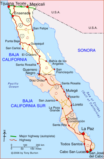 Maps
MapsMany large grocery stores or book stores in the Baja sell basic Baja California maps for a few bucks. REI in San Diego (in 2013) had National Geographic maps with topographic lines at 100 m intervals. Detailed road maps for all of Mexico produced by Mexico's' Department of Transportation have been posted online by a Bicycle tourer named Nico. They are listed by state and can be downloaded for free from here: https://www.dropbox.com/s/o4z2617gtbcecap#view:list
Water
Carry lots of water if your are uncertain where the next refill opportunity is and do not drink the tap water. I carried up to 11 L (perhaps excessive! - my friend drinks less water and did okay with max 6L) through some remote areas in the middle. Most markets in the Baja have purified water refill stations, which usually charge about 5 pesos ($.50) to fill a gallon jug. I highly recommend stopping in a refill stations (agua purificada) as this option is much cheaper than buying a fresh bottle each time and it greatly reduces your plastic waste. Carrying your own filtration system (many options available these days) for tap water will save a few bucks.
Drink lots of water but also be mindful of over hydration caused by excessive water consumption leading to decreased salts in your blood. Eating food, especially fruits and vegetables, or consuming other sources of electrolytes is how your body restores salt lost at increased rates during cycling in the dry heat.
Traffic
Our experience was that most drivers kindly passed us with ample room and safety when it was possible and sometimes slowed down to wait until they could safely pass. The Mexican motorists were extremely cheerful towards us, often honking and waving enthusiastically.
 |
| A section of some fairly unpleasant riding in Northern Baja |
Regardless of where I am touring, I adopt a defensive riding style and try as much as possible, to assume responsibility for my own safety.
Similar to how mountaineers manage their risk against objective hazards such as rock fall and avalanches, bike tourers should have some basic understanding of how to manage their risk against accidents with traffic. Risk is conceptually calculated as the probability of an accident occurring multiplied by the severity of the potential accident (risk = probability x severity). The severity of being struck by traffic is obviously huge as it is likely your health or at least your bike that may be impacted. The probability of being struck by a single car is very low but the probability of this happening stacks up on a long trip when you are passed by hundreds of cars each day. Also, the probability of this is highly variable due to random road condition and the experience and state of the driver. A very tired or drunk driver may be reasonably likely to hit a cyclist compared to someone in a sharper state.
Cycling safety tips
-Always take breaks cleanly off the road way
-Travel with a rear view mirror and keep track of who is passing you.
Especially when there is oncoming traffic in the opposite lane, watch to see who may be coming up behind you. If large trucks or a long line of cars is passing you, or if it may be difficult for approaching cars to see you, then consider pulling off the road. Without a mirror, it is difficult to keep aware of who is passing you.
-If two trucks, in opposite direction, happen to pass in the same moment then is no space for you to be on the road and you should immediately pull over, and lean off the roadway
- listening to cars past is a helpful tactic to perceive hazards coming from behind but if you are in strong, noisy winds, then you lose this ability and a mirror is needed.
- When large vehicles are approaching to pass, especially around blind corners (which they will do), consider making a quick pull over to give them room.
- use typical safety gear, including helmets and bright clothing
- don't ride at night or at dusk
The Baja cycling route is gaining popularity. As such, here are two other helpful guides:
The rough guide to cycling Baja contains useful tips, including advice when to go, and how to get off the main highway onto backroad routes.
For fun, and in case your not convinced yet, here are 5 reasons to cycle Baja.
Baja California Cycling Guide
The guide below is arbitrarily split up into various sections that may or may not be single day rides. the info provided is extremely limited and a result of my single time riding the peninsula. Nonetheless, it should be helpful for planning trips and helping people find the things they need and stay safe. Always the best thing to do is ask the locals about safety and services on the road ahead.
Tijuana to Ensenada: 113 km
On this section of the trip you need to have your wits about you and a plan for the day. Tijuana is a a fairly sketchy border town and the ongoing drug war is active in these northern border towns, though, it should theoretically not affect tourists.
Upon leaving the border the street activity is buzzing and the people selling various things or distracting your attention can be nearly overwhelming. Keep careful eye on your things and have a good sense of where you need to go.
Their are two options for leaving Tijuana and traveling to Rosarito. The toll highway ("carretera de cuota") forbids cyclists but offers a safer, flatter more scenic route so many cyclists go for it. The majority are able to pass by the tolls and ride to Rosarito but some, like ourselves, are stopped by guards. After getting stopped we asked a local man if he could drive us and he was nice enough to take us all the way to El Rosarito. Taxi may be an option in this situation. The free highway ("carretera libre") heads through the hills and sees a lot more traffic. Note that that paths leading to each respective highway diverge almost immediately upon entering Tijuana so have a preplanned route in mind before hand. The third option is that you can take a bus called 'ABC' (Autotransportes de Baja California) direct to Ensenada. Their terminal is located very near to the border, beside McDonalds. According to a comment by Hernandez, you can take your bike in the luggage compartment. I've done this a few times in other places, but do caution that my bike has been damaged in these compartments.
This might all sound kind of scary but its not too bad and an exciting way kick off the adventure!
At around km 30 depending on your route is a fun ride through the streets of el Rosarito, which has beaches, motels and everything you need
30-71 km the free roadway, where bicycles are permitted, runs parallel to the toll road and has less traffic. This is quite nice riding along some steep slopes that head down to the shore below. Some tiendas and cafes are scattered as you go.
71-101 km I am not sure what the toll road is like for this section. The free road heads inland past the town of la Mission taking you to a serious hill climb out of the valley bottom and up onto a plateau. The road continues with some more climbing and finally a nice long descent back to the coast.
101-113 km a short section of riding along the coast with a good shoulder brings you into Ensanada, which is many times calmer and more inviting than Tijuana but is still a big busy city close to the border.
 |
| Descending towards Ensenada |
0-16km the road out of Ensenada to nearby suburb Rodolfo Sanchez Taboada is quite urban and busy the whole way. It's somewhat sketchy but at the same time a little bit fun and exciting to be part of the chaos. There is a free house for cyclists to stay in the suburb Rodolfo Sanchez Taboada, but you should have an account on warmshowers.com and email the host at least a few days in advance for directions.
16-21km
The road out of this suburb is chaotic. It's two lanes were absolutely choked with trucks when we were on it. But you must survive because its about to get better.
21-46 km the road heads island into steep valleys. The hill climbing is substantial but the road is freshly paved with a wide shoulder. This is some of the best road we had on the whole peninsula. Santo Tomas is located at around 46 km and has two basic markets and at least one restaurant. I think it also has a camping area though am not sure about that.
46-84 km the road between Santo Tomas and San Vicente is remote and a good introduction to the Baja desert wilderness. there are some big hills and no services.
San Vicente is a large town with a wild west feel. It is apparently not safe to camp anywhere around town and we experienced a concerning threat of having our bikes violently robbed while we were in the town. There are several hotels. We really liked one half way through town on the left side of the road, beside a pharmacy. It was cheap but clean and comfortable. We left early the next morning, cycling fast.
 |
| A Large hill drops towards San Vicente after a section of farily remote riding. |
San Vicente to El Rosario : 165 km
 |
| Along the coast just before heading inland to El Rosario |
0-37km easy flat riding to Punta Colonet, a small town with numerous places to eat and markets to get supplies.
37-82 km more easy terrain with bad traffic. There are some additional towns along this section to get supplies or stop for lunch. Vicente Guerrero at km 82 is a large enough town to have big supermarkets and several hotels.
82-107 km more easy terrain to Lazaro Cardenas another large town. Their are two camping options just 2 km past the town. The second, Los Oliveros, is very nice with camping among Olive Trees, fire pits, cooking areas, hot water and wifi. They were asking 120 pesos each but we ended up paying about 70 each.
107-165 km a 5 km detour to the sea from Los Pinos ( about 12 km past Lazaro Cardenas) is another nice option for camping, though the only nearby store is at Los pinos itself. The terrain remains easy riding except some good sized hill climbs are required to pass the dry ravines that drain out the mountains on your left. As the road leaves the ocean towards El Rosario you start a long and tough hill climb that takes you up onto a plateau. The downhill is superb and through beautiful canyon scenery. at the bottom of the hill is El Rosario. The market immediately on the left is quite good and there are more options as well as internet ahead in town. Watch this film which begins with the awesome descent into El Rosario. (just be warned that it then backtracks to teh descent into San Vicente before getting back on track towards Catavina
El Rosario to Catavina : 123 km
This was beautiful but a really tough section of road for us. It is endlessly hilly, gains substantial elevation overall and we had strong headwinds for the entire ride. It sounds from other cyclists reports that strong headwinds from the north east are commonly encountered along this stretch.
There are three small cafes located along the road but nowhere to stay and no stores to buy provisions. I can't recall the names of the first two but they were located around km 30 and 50. A third cafe is called Guiyaquil at around km 75. The road gets less hilly about half way through the day and towards the end you enter a stunning desert with large boulders scattered throughout and sometimes piled up into enormous mounds. It is unbelievably interesting. The whole ride is a special one through remote hilly desert.
Catavina has a decent market that has marked up prices and there are two hotels. the first is on your left as you enter town and costs about 300 pesos for a night, the other one cost over 1000 per nit and is ahead on the right.
There is a camping area located inside the town and also one just before entering town on the left. One local told us it was not safe to camp in this town but he was a bit crazy, and also told us about his encounters with UFOs out in the desert. Another, more trust worthy local told us their is some risk of being robbed while camping in the area. Probably the campsite in town is fine, just keep an eye on your things.
 |
| Quite a surreal landscape before entering the tiny village of Catavina. This is some of my favourite Baja scenery |
 |
| Near Catavina |
Catavina to Punta Prieta : 119 km
0-52km you have some fairly large hills to climb through totally uncharted desert of quite interesting scenery. At 52 km there is a very cool little cafe at the dry lake bed of Laguna Chapala. When we were there they were well stocked with juice and water that was quite expensive but well worth it.
 |
| Cirrio or Boojum tree (Fouquieria columnaris) |
52-106 more remote desert with no services. There is just one good size hill and then you have a long straight slightly downhill road through el Valle de Los cirrios. The cirrios, or Boojum trees in English, are the tall, bendy, often awkwardly leaning plants up to 20 m tall that you may have noticed growing in the deserts since el Rosario a couple days ago. They exist nowhere else on Earth and are actually trees as opposed to cactuses because they are supported by a woody stem and are sufficiently tall to qualify as trees. At the end of this long straight away is a junction to Bahia de Los Angeles and there is a decent campground. I am not sure if supplies are available in this village.
106-119 km flat riding with a few more turns then the previous section. At the end of this is Punta Prieta a town with several small stores and a 24 hr restaurant on the far side of town. There is no camping or hotels but the locals are friendly here and may let you camp in their yard. Local people told us it was safe to camp anywhere around this area. I used my little portable radio this morning to tune into the US election results. Obama was elected and I rode onwards with optimism for the world.
Punta Prieta to Guerrero Negro : 123 km
0-48 km somewhat hillier than the previous day. Restaurants and tiendas once you arrive to Rosarito at km 48 or so
48-88km quiet desert that gets flatter and flatter. At the military check point about halfway down this section you could consider making the 6 km detour down rough sandy road to camp on the beach at Las Esmeralda's. Villa Jesus Maria is at around km 88. Here there is a gas station, stores and an excellent fish taco shack located immediately on the left when you approach the gas station. These women don't mess around with the chile sauce, its killer hot!
88-125km you are now well into the Vizcaino desert and it is unbelievably flat. A massive Mexican flag appears dead ahead but don't focus too much on it as its still a very long ways away. It's another few kilometers into Gurerrero Negro and on the way you will pass an RV park that did not look very hospitable for tenters as seen from the road.
 |
| Be patient here because that flag is WAY farther away than it appears. Approaching Guerrero Negro. |
In Guerrero Negro is not really beautiful but its a nice place to rest out of the desert. Whale watching is big business here from December15 to April 15. There is a large supermarket about 1.5 km after entering town on the right hand side. Next to this is hotel MGM, which has basic but alright rooms for 245 pesos for two beds. Most other hotels are charging at least a bit more. There is a helpful bike mechanic in town that had inner tubes and spokes for 700 cc and they helped engineer a clever solution to my back rack problem. To find the mechanic continue on the main street into town two blocks past the mercado and MGM Hotel, hang a right and go one and half blocks. The mechanic is in a little yellow plywood shack with a big window that opens up to the parking spot. Otherwise ask the locals for el mechanico de bicicleta? If you were to stick on the Main Street past the turn for the mechanic there are cheap little lunch shacks. Tony's tacos, with a blue awning serves up the biggest fish tacos I've yet seen for the low price of 10 pesos($.80).
A coffee shop on the right soon after entering town has a computer with good Internet and also wifi. They also have delicious cheese and ham baked buns.
 |
| Long flat sections through the Vizcaino Desert |
Guerrero Negro to Santa Rosalia : 220 km
The road and desert are very flat until just before San Ignacio when some mesas start rising up from the desert and the road becomes quite hilly about 20 km from San Igancio. From there the road climbs gradually with a few downhills until arriving at the cliffs above Santa Rosalia that give way to a spectacular twisting downhill on fresh, smooth pavement.
0-35km the Vizcaino desert is extremely dry and sparsely vegetated here. A small town with a very basic store is located along the highway.
35-75 km as I recall there is nothing until after the road veers more south and does another 15 km or so to the town of Vizcaino, which is fairly large with hotels and other services. I don't think there is camping...? It is windy when we here and tumble weeds were blowing down the main street. Continue into town almost 1 km and there is a large supermarket on the left and just before it a smaller one on the right. Between these two mercados there is a small yellow building with a red smoke stack and they roast up delicious chicken (featured in my Baja Sur film).
75- around 120 km more flat desert with a couple tiny hill climbs. A few attractive mesas appear like islands in the middle of the desert. To the north are mountains and one attractive mountain has a long slope to the west and then an abrupt drop on the eastern side. At around 120 km there is a small cafe that is reliably open.
120-145 km this section starts flat then gets into some big hills that drop in and out of ravines. San Ignacio is located a couples km off the highway, but there is a cheap motel just pass the turn for San Ignacio and also a reasonably priced (300 peso for two bed rooms) but very nice motel just 100 m along the road that leaves the highway and heads into San Ignacio. We ate at the restaurant at this motel and the owner came out and explained to us that he held the Mexican record for most continuous hours spent on a unicycle: 56 hours! The old circus vet then serenaded us for an hour with an unusual string instrument. The food was good too.
 |
| Approaching San Ignacio though fairly lush desert vegetation |
145-220km The road starts with a moderate hill climb and then eventually gets onto a long gradually rising straight away that leads you towards the conical Volcan de Las tres Virgenes 1940m. Passing this volcano the road climbs more and then puts you into a fun downhill.
At around km 200 the sea comes into view and you have a spectacular downhill ride, one of the best on the coast. Then a short ride past mines and industrial water front and you are in the old french mining town of Santa Rosalia.
Santa Rosalia has a nice urban feel to it and there are some decent hotels, to stay but no camping.
Santa Rosalia to Loreto: 200 km
0-63km the road to Mulege is mostly flat until climbing a moderate hill as you approach Mulege. We did this scenic section fast and there was few or no services after the initial few kilometers south of Mulege. Mulege is a beautiful little town set in steep somewhat humid mountains. About 100 m after entering town there is Mario's taqueria on the left side, which some Canadians we met claim has Baja's best tacos. They were a bit pricey but indeed incredible. Continue southbound, leaving the highway under the large arch and there is a pretty good market with cheese, meat, water refills etc ahead on the left. Make sure you take enough to spend the night camping on the beautiful beaches ahead.
63- 120 km beautiful camping on white sand beaches begin about 20 km outside Mulege. Skip the first one and at least head to Playa Santispac, which is a beautiful sheltered bay and the restaurant in the middle of the beach serves up huge piña coladas for 50 pesos. All camping spots cost between 60-100 pesos along the Bahia but bargaining seems to work : "hay descuento para bicicleta?"
 |
| Playa Santispac, the second one reached cycling south from Mulege |

120- 200 km Bahia de Concepcion to Loreto.
After leaving the bay the road ascends a substantial hill. From the top you have a fine view of the expansive and quite flat valley you will follow for the next 50 or 60 km (photo above). The final 20 or 30 km into Loreto takes you through some small rolling hills. There was at least two cafes along this I stretch but all were closed and appeared to be seasonal or are permanently closed
Loreto to Ciudad Constitucion: 150 km
Loreto has every thing you need, including a bank, cafes and basic tiendas located along the highway. Everything else may be a little further into town where it's apparently pretty nice. I just cruised through but I was informed that there is an RV park near the highway and a better one called Riveria de la Mar that is closer to the center of town.
0-25 km mostly easy riding with a couple moderate hills to Juncitos where there is excellent camping. Take the left turn 200 m past the left turnwhere the Juncalito sign is located. You may have to pay but I arrived late and nobody was there to collect. There will likely be other people already there.
Km 26 there is a turn off to puerto Escondido, which I heard from some Canadians is a cool spot and that is all I know about it.
Km 40-45 you have begun an enormous hill called La Cuesta de Ligui. Any hill that has a well known name is going to be big and I'd say this is much bigger than anything else on the Baja or along the coast of the United States. Good luck!
 |
| La Cuesta de Ligui, the worse half of it anyway... Have fun! |
km 55 from the top of the hill there is nice desert mountain scenery and some more rolling but significant hills, then there is a restaurant called Aguas Verdes I didn't stop at that may have water and other basic provisions. About 4 km later is another cafe run by an attractive Mexican women. They have chips and basic Mexican food.
 |
120km in ciudad insurgentes I believe there is at least one hotel, if not more, but no camping, despite what the recreation map says. I ate some delicious ceviche before leaving town from a street vendor and there are various options for this.
120- 128 km to ciudad constitucion is more of the same: flat, flat and flat. In ciudad constitucion there is an awesome rv park called Mision soon after entering town on the left with a fancy gate over it. It looks American but it is run by a very nice Mexican family and has wifi and hot showers. It costs 100 pesos, but I bargained down to 80.
This is a relatively big city with large supermarkets and street food galore. I would be surprised if there was not some form of bicycle store within.
Ciudad Constitucion to Las Pocitas : 96 km
0-55 km flat riding with more or less no amenity until Santa Rita where there are a couple cafes and Tiendas with very basic selection.
55-80 km around km 80 a tienda appears on the left that for me was closed and then later one on the right that was open.
80-97km terrain is getting a little more hilly as you enter las Pocitas. Down the hill is a gas station where there are a couple restaurants and basic tiendas with jugs of water, ice cream and whatever you need. A couple blogs have reported that camping at the church is a possibility. Just ask people for the priest (El Padre). We asked a police officer if he knew where we could camp and he invited us to camp behind the police station.
Las Pocitas to La Paz: 112 km
This is a surprisingly hilly section of riding with some reasonably nice scenery but you will certainly be glad when its done. We were very much so since the Baja 1000 off road race was coincided with our riding and it was extremely dangerous. Watch the film if you have not yet.
0-10km La Cien is a tiny village with an abandoned gas station and a couple stores serving food or selling basic items.
10-30 km a few stores and cafes are spaced along the road until a final restaurant with a Cerveza Pacifico sign. This is your last chance for beer until reaching the villages near La Paz.
30-95 nothing but rolling desert and a a single tiny store somewhere around the 70 km mark. I would not count on it for anything important. At around 90 km the large ocean bay where La Paz becomes visible but its not as close As I had hoped. A nice downhill then a long strait away until the ocean where fish tacos, and supplies become abundant.
95-112 km about 6 or 9 km along is an RV park on the right. The cafe beside it has wifi. The ride into town is alright, just follow signs for the center (el centro). I personally like Pension California as a place to stay. As far as I know it's the closest thing to a hostel in La Paz and not overly expensive (300pesos for a two bedroom) given its prime location. Now it's time to enjoy the unlimited amenity of the big city. Diverse food and drinking options are available. Go on, you have certainly earned it!
Now the adventure begins?
What I mean by this question is: now do you go home, or do you catch the ferry over the mainland and keep biking? I recommend that you keep going! On the mainland you will discover Mexico all over again —there are fewer tourists, less American influence, it's less expensive, more tropical, and it has a more authentic Mexico feel to it. I kept going and cycled the entire Pacific Coast of Mexico, cut north, went around the Yucatan, then cycled south east to Panama. I blogged about it here during what I dubbed Mission Rainbow. Whatever you decide, I hope that you found this blog useful. Ride on!